Mapping and measurement of tropical coastal environments with
hyperspectral and high spatial resolution data
See: International Journal of Remote Sensing, 18 (2): 237-242. (1997) for further details of this research.
Description
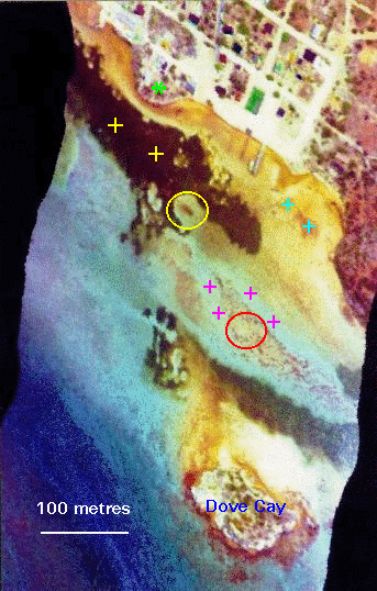 The image to the right is an
airborne multi-spectral image of seagrass and reef habitats
of the shore of South Caicos, British West Indies acquired by mounting a CASI (Compact Airborne
Spectrographic Imager) sensor onboard
a light aircraft (see Table 1). The small
island in the south is Dove Cay. The very high resolution (1
m by 1 m pixels), permits 'blow-outs' in the seagrass meadows
and individual coral reef heads to be detected. The image is
a colour composite using two blue and one green waveband and has
been decorrelation stretched to maximise colour separability.
Specific habitats are marked on the clickable map:
The image to the right is an
airborne multi-spectral image of seagrass and reef habitats
of the shore of South Caicos, British West Indies acquired by mounting a CASI (Compact Airborne
Spectrographic Imager) sensor onboard
a light aircraft (see Table 1). The small
island in the south is Dove Cay. The very high resolution (1
m by 1 m pixels), permits 'blow-outs' in the seagrass meadows
and individual coral reef heads to be detected. The image is
a colour composite using two blue and one green waveband and has
been decorrelation stretched to maximise colour separability.
Specific habitats are marked on the clickable map:
 yellow crosses = seagrass meadows;
- yellow circle = seagrass blow-out;
- cyan crosses = calcareous green algal habitat;
- magenta crosses = soft corals on bare substrate;
- red circle = Montastraea reef habitat;
- light green star on headland = view southwards across area of image.
Recent enhancements to the hardware
and software of the CASI system have produced a significant reduction
in the integration time, which has improved its overall spectral
and spatial capabilities. it is now possible to acquire square
pixels of 1 m resolution, and to acquire a higher number of wavebands
for a given swath width.
Utilising this new potential, south
to north flights were made over Cockburn Harbour, South Caicos
Island, British West Indies. Individual roof-tops, trees, and
large coral heads are visible and a boat can be observed moored
alongside a jetty. Eight wavebands were chosen between 402 and
785 nm using wavelengths that would provide good water penetration
and also be of use for infrared sensing of mangrove and other
terrestrial vegetation (Table 1). The east and west edges of the image
are curvilinear because each scan line has been relocated to adjust
for the effects of the aircraft. This was achieved using data
from an onboard gyroscope which monitored the lateral roll during
flight.
As with many tropical waters that are remote from sources of suspended
sediment such as rivers, the clarity of the water is exceptionally
good. Water depths vary from a few centimetres at the coastline
to over 15 m in the southwest of the image, although for most
of the area the depth is less than 5 m.
Whilst some of the variation in colour results from bathymetric
variation the dominant control is the nature of the marine habitats.
Large meadows of seagrass are evident (marked by yellow crosses) in oblique aerial
photographs and the CASI imagery.
These are high biomass mixed stands of the turtle
grass Thalassia testudinum, and manatee grass Syringodium
filiforme. The high spatial resolution permits
individual 'blow-outs' (Zieman 1982) to be detected, which may
vary between a few metres in diameter to tens of metres. They
are important for seagrass dynamics as they provide a record of
destructive events, and may act as a foci for seagrass loss and
erosion of the substrate (Zieman 1982). The yellow circle marks a large blow-out feature. Much of the lighter brown
in the image represents lower biomass seagrass stands.
The textured brown and tan patch with the red circle at its centre
marks a zone of large coral heads, dominated by the species Montastraea
annularis and Porites porites .
The high
resolution permits the mapping of this reef habitat and even the
location of individual reef heads which are typically only 1-3
m in diameter. The brown-red coloration around the southern shores
of Dove Cay demarcates a more diverse reef habitat with large
colonies of Acropora palmata dominating the near shore zone.
The darker blue in the south-west of the image represents
the deeper waters of so-called Shark Alley.
Table 1. Image acquisition details
Sensor: CASI (Compact Airborne Spectrographic Imager) |
| Spatial resolution | 1 m resolution |
|---|
| Spectral resolution |
8 wavebands: 2 blue, 2 green, 2 red, 2 near-IR, varying
from 8 to 20 nm in width. |
|---|
| Waveband settings (nanometres): |
|---|
| 402.5-421.8 | 453.4-469.2 | 531.1-543.5 | 571.9-584.3 | |
| 630.7-643.2 | 666.5-673.7 | 736.6-752.8 | 776.3-785.4 |
| Platform | Cessna 172N (a single engine, high wing light aircraft with four seats)
|
|---|
| Altitude | 2750 ft (840 m) |
|---|
| Date | 10 a.m. 16 July 1995 | Return to text |
|---|
The aircraft was locally loaned and not specifically adapted
for aerial survey work, and so had no observation hatch. We mounted
the sensor by fitting a specially designed door with incorporated
mounting brackets and a streamlined cowling. Power for the operation
of the sensor was provided by a heavy-duty aircraft battery, as the electrical supply of the aircraft was inadequate.
An incident light sensor (ILS) was fixed to the fuselage so that simultaneous
measurements of irradiance could be made. Profiles of irradiance
and temperature change between ground level and the image acquisition
altitude were also recorded. A DGPS (Differential Global Positioning
System) was mounted to provide an accurate record of the aircraft's
flightpath. The use of a local aircraft and pilot with the
adapted door mentioned above allowed us to acquire image data
at a fraction of the cost of more usual methods which utilise
specialist survey aircraft, instrumentation and experienced survey
pilots.
The CASI data presented here is only a small part of that collected by the project:
The following missions were executed:
- High spatial resolution: 1 m pixels, 8 wavebands (as
illustrated)
- Hyperspectral: 288 wavebands for a 120 m swath, with
3 m pixels; and 144 wavebands for a 300 m swath, with 3 m pixels.
- Marine bandsetting: 16 wavebands optimised for mangrove
mapping and assessment, with 3 m pixels.
Context
The objectives of our research are to evaluate satellite and airborne
remote sensing sensors with respect to their abilities to achieve a suite
of defined coastal resource management objectives. This involves
technical evaluation in terms of how accurately resources can
be mapped and measured, and an economic evaluation that documents
the costs of achieving these outputs.
 The work is restricted to tropical coastal environments and is
mostly concerned with reef and seagrass habitats, coastal wetlands
and mangroves. Our test site extends over a large part of the
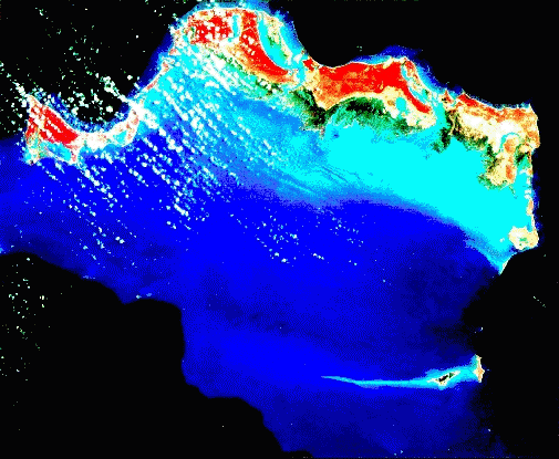
Caicos Bank (see image to the left), situated in the Turks and Caicos Islands of the British
West Indies (71° W, 21° N). Imagery being evaluated
include Landsat-MSS and TM, SPOT XS and Panchromatic,
aerial photography, and airborne CASI.
The work is restricted to tropical coastal environments and is
mostly concerned with reef and seagrass habitats, coastal wetlands
and mangroves. Our test site extends over a large part of the
Caicos Bank (see image to the left), situated in the Turks and Caicos Islands of the British
West Indies (71° W, 21° N). Imagery being evaluated
include Landsat-MSS and TM, SPOT XS and Panchromatic,
aerial photography, and airborne CASI.
CASI data were obtained to provide a high resolution best-case
assessment of 'truth' for relatively small (10 km²) areas
subject to intensive fieldwork (>200 person-days). Together,
these provide detailed quantitative information on cover etc.
This is being used to test the accuracy of outputs derived from
analysis of coarser spatial and spectral resolution satellite
imagery. In addition the ability of CASI to provide detailed
information relating to habitats and communities of interest to
coastal managers is being assessed.
References

|
GREEN, E.P., MUMBY, P.J., EDWARDS, A.J., and CLARK, C.D. 1995,
A review of the application of remote sensing for tropical coastal
resource assessment and monitoring. Coastal Management, 24, 1-40. |
|
ZIEMAN, J.C., 1982, The ecology of the seagrasses of South Florida:
a community profile, U.S. Department of the Interior, Bureau of
Land Management, Fish and Wildlife Service (FWB/OBS-82/55) | .
Acknowledgements
![[ODA logo]](../webgif/dfid.gif) This research is funded by the U.K. Department for International Development's
Environment Research Programme. We are very grateful to the Turks
and Caicos Islands' Ministry of Natural Resources for their logistical
assistance in our fieldwork, and in particular to Mr John Ewing,
Mr Christie Hall, Dr Paul Medley, Mr Chris Ninnes, and Mr Perry
Seymore, and to Jean-Pierre Angers for the loan of the modified
Cessna door. Angie Ellis is acknowledged for her untiring assistance
in the field, and Dr Steve Plummer for some useful advice.
This research is funded by the U.K. Department for International Development's
Environment Research Programme. We are very grateful to the Turks
and Caicos Islands' Ministry of Natural Resources for their logistical
assistance in our fieldwork, and in particular to Mr John Ewing,
Mr Christie Hall, Dr Paul Medley, Mr Chris Ninnes, and Mr Perry
Seymore, and to Jean-Pierre Angers for the loan of the modified
Cessna door. Angie Ellis is acknowledged for her untiring assistance
in the field, and Dr Steve Plummer for some useful advice.


© A.J.Edwards, 1997