|
|
Staff involved:Alasdair Edwards, Edmund Green, Peter Mumby, Chris Clark (Sheffield)Funding:Department for International Development (DFID)
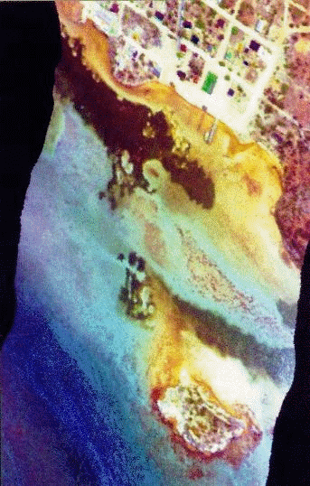
Compact Airborne Spectrographic Imager (CASI) image of seagrass and reef habitats off the shore of South Caicos. The small island at the south is Dove Cay. The very high resolution (1 m pixels) permits 'blow outs' in the seagrass meadows and large Montastraea colonies to be detected. The image is a colour composite using two blue and one green waveband and has been decorrelation stretched to maximise colour separability.
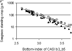
Regression of the logarithm of seagrass standing crop (g/m²) on processed CASI data (depth-invariant bottom-index generated from bands 3 and 5) showing upper (squares) and lower (triangles) confidence limits. Band 3 was set to 531.1-543.5 nm and band 5 to 630.7-643.2 nm. |
Evaluation of the uses and cost-effectiveness of remote sensing for coastal resources assessment and mappingProjectThis project was funded by the UK Department for International Development (formerly ODA) for three years from September 1994. The research evaluated a range of satellite and airborne remote sensing technologies with respect to their abilities (measured in terms of accuracy of outputs) to achieve a suite of defined coastal resource management objectives. This technical evaluation was undertaken in parallel with an economic evaluation of the capital investment, operational, institutional, human resource development and training costs of applying the technologies effectively. Fieldwork was conducted in the Turks & Caicos Islands in collaboration with the TCI Ministry of Natural Resources and in Belize with the collaboration of the Belizean Coastal Zone Management Unit and Coral Cay Conservation Ltd. The results were published as a series of 11 papers in international scientific journals, three papers in conference proceedings and two articles in remote sensing and GIS technical magazines. They are summarised in a 316 page practical manual Remote Sensing Handbook for Tropical Coastal Management targetted at resource managers, environment departments, coastal zone planners, coastal wetland and marine park managers, and environmental consultancies and NGOs working in developing nations. This was published by UNESCO in early 2000. Training materials were also produced for UNESCO's Bilko remote sensing distance-learning package to accompany the handbook. These are available on CD-ROM with an accompanying 185 page booklet (Applications of Satellite and Airborne Image Data to Coastal Management) published as volume 4 in the Coastal Region and Small Island Papers series of UNESCO in 1999 (reprinted twice). A revised and expanded version was published in 2005 in the same series (Volume 18). SignificanceThe coastal environment and its resources are under strong pressure from population growth, industrialisation and tourism throughout the developing world. Integrated management is widely recognised as the basis for sustainable use. The first step towards this generally involves an evaluation and mapping of the resources using remote sensing techniques ranging from aerial photography to satellite imagery. These technologies are potentially a great boon to developing nations wishing to improve management of coastal resources. However, despite their increasing use, there was, until this project, no rigorous analysis of the relative costs and benefits of using different types of satellite and airborne imagery. Furthermore it was unclear which coastal management objectives could practically be achieved using a given technology with a given level of inputs (e.g. ground-truthing, image processing). Future directionsFollowing the project it is now possible for planners, consultants and decision makers working in developing nations to decide:
References
|