Cold Regions
About
Cold regions research in Newcastle Physical Geography addresses questions with major societal impacts, such as sea level rise, water resources and natural hazards. Our work integrates field research, remote sensing and numerical modelling, to further our understanding of cold-regions and their response to climate change. We work globally, with research sites including Antarctica, Greenland and the Himalaya. Our research encompasses a range of sub-themes, including glacier response to climate change, glacial lake outburst floods, hillslope processes and periglacial landscapes.
A new approach to West Antarctic Ice Sheet evolution using blue-ice moraines on nunataks
Location: Ellsworth Mountains, Antarctica 80°19'53.00"S, 81°36'46.00"W
Newcastle staff: Dr Stuart Dunning
External collaborators: Prof John Woodward, Dr Kate Winter (University of Northumbria); Prof. David Sugden, Dr Andy Hein, Dr Shasta Marrero (Edinburgh University)
Project outline: Did the West Antarctic Ice Sheet (WAIS) survive the last interglacial? We propose to use nunataks as dipsticks of ice-sheet elevation change to help answer this question. There are currently two conflicting hypotheses:
Hypothesis 1: A dynamic WAIS. The hypothesis is that the WAIS disappeared under last-interglacial conditions ~125,000 years ago when climatic and oceanic conditions were slightly warmer than those of the present day.
Hypothesis 2: A stable WAIS. The WAIS may have varied in elevation but that it persisted as a coherent ice sheet during the last interglacial.
This project brings together glaciologists, geomorphologists and geophysicists to work in the Heritage Range, a group of nunataks which protrude through the central WAIS dome. We will test predictions of the two competing hypotheses firstly by examining the processes of blue-ice moraine formation today using field survey and radar, and secondly by establishing the form and sediment characteristics of the moraines and their age. The latter will employ exposure-age dating, a technique that measures the time a rock has been at the surface and exposed to cosmic rays. By using more than one isotope we can establish times when a rock surface may have been buried by ice and thus there is the potential to reconstruct a rich history of ice elevation changes. In this way we will assess if the WAIS remained intact, or disappeared during the last interglacial. Our hope is that the approach could be extended to other nunataks in Antarctica and provide widely dispersed evidence of elevation changes in predicting the future response of the WAIS to a changing climate
Acknowledgments: This research was supported by a National Environmental Research Council Standard Grant NE/I025840/1
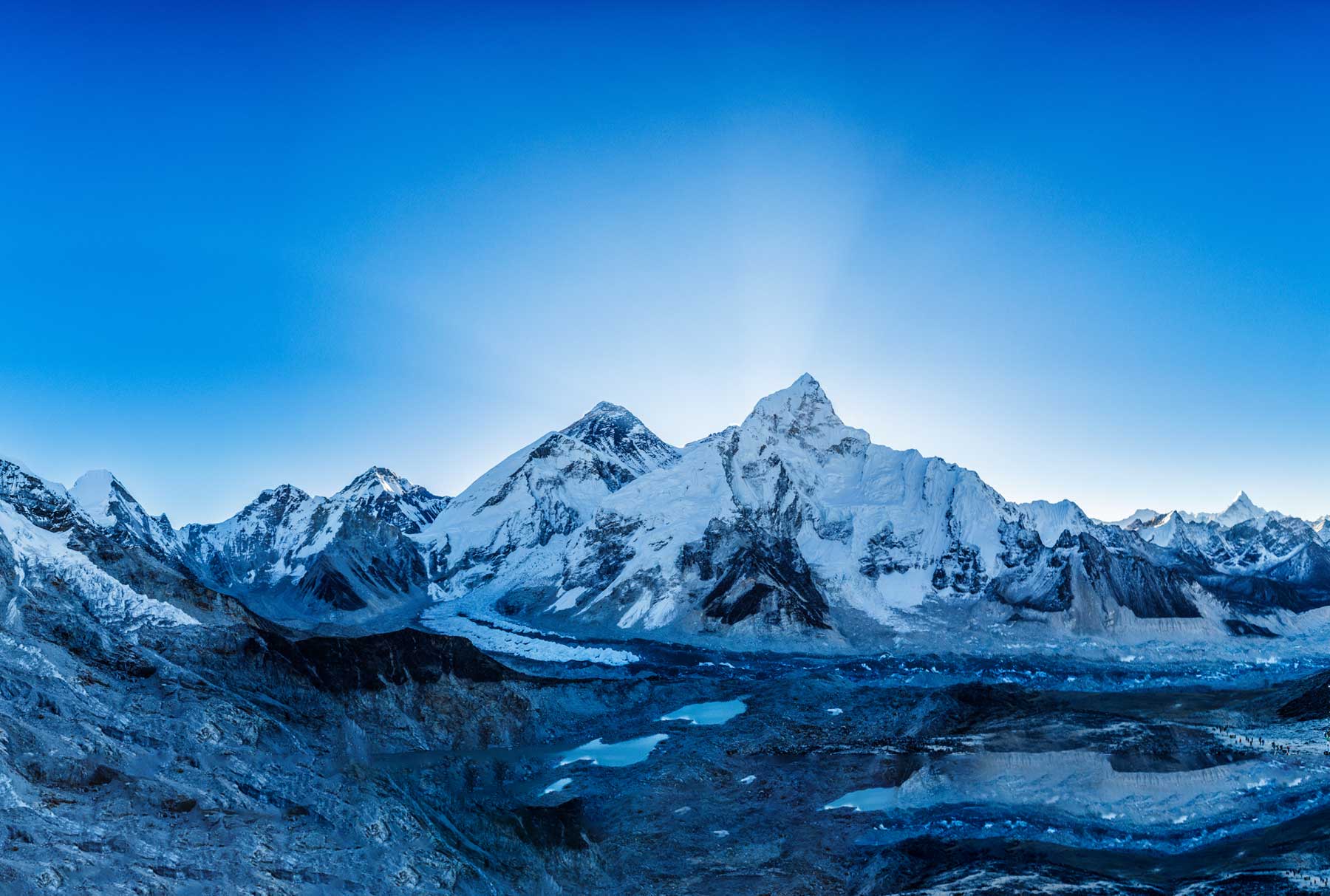
Impact of debris cover on Himalayan glacier response to climate change
Location: South Annapurna Glacier, Nepal, 28°32'11.03"N, 83°52'24.41"E
Newcastle staff: Dr Rachel Carr
Post-graduates: Arminel Lovell, Emily Hill
External collaborators: Alex Cumming (University of Leicester)
Project outline: The aim of the project was to assess the impact of debris on the melt rates of Annapurna South Glacier, Nepal. This involved two weeks of fieldwork at the glacier, in October and November 2016. In order to evaluate the impact of debris cover on melt rates, we drilled a series of stakes into the glacier ice and measured how much the surface melted over time. We assessed the debris thickness and characteristics (grain size, packing, moisture content) at these sites, so that we could relate the debris characteristics to melt rates. We also studied how the ice surface changes over time, using a survey-grade GPS and the Structure from Motion technique, which allows us to make models of the surface topography from photographs. Together, this information will improve our understanding of the impact of debris on Himalayan glaciers, which is vital for forecasting future water resources and contribution to sea level rise.
Acknowledgments: This research was supported by Newcastle University Faculty of Humanities and Social Sciences Faculty Research Fund (RC) and a National Environmental Research Council PhD studentship (AL).
Response of outlet glaciers to climate change on Novaya Zemlya, Russian High Arctic
Response of outlet glaciers to climate change on Novaya Zemlya, Russian High Arctic
Location: Novaya Zemlya, Russian High Arctic, 74 – 76° N, 56 – 68° E
Newcastle staff: Dr Rachel Carr
External collaborators: Chris Stokes (Durham University), Andreas Vieli (University of Zurich), Heather Bell (Durham University), Rebecca Killick (Lancaster University), Tom Holt (Aberystwyth University).
Project outline:
This project aims to quantify retreat rates on Novaya Zemlya outlet glaciers, and to relate observed changes to climatic forcing. Arctic ice masses have rapidly lost ice from the mid-1990s, through a combination of negative surface mass balance and accelerated ice discharge from marine-terminating outlet glaciers. In the past decade, the northern ice cap of Novaya Zemlya underwent substantial mass loss and accounted for 80% of all ice loss from the Russian High Arctic. However, our understanding of the behaviour of Novaya Zemlya’s outlet glaciers is limited, despite their potential to contribute substantially to sea level rise. This project uses a range of remotely sensed data to assess outlet glacier retreat rates and its possible causes. Results demonstrate accelerated retreat from 2000 onwards, which coincided with major reductions in sea ice concentrations and atmospheric warming. Since 2013, retreat rates have slowed substantially and several glaciers have begun to advance, although further study is required to determine whether this represents a longer-term term trend or a short-term hiatus in rapid retreat.
Publications: Carr, J.R., Stokes, C.R. and Vieli, A., 2014. Recent retreat of major outlet glaciers on Novaya Zemlya, Russian Arctic, influenced by fjord geometry and sea-ice conditions. Journal of Glaciology, 60 (219) 155-170.
Evaluating the impact of a proglacial lake and debris cover on ice loss from Russell Glacier, west Greenland
Evaluating the impact of a proglacial lake and debris cover on ice loss from Russell Glacier, west Greenland
Location: Russell Glacier, central-west Greenland
Newcastle staff: Dr Rachel Carr
Project outline: This project aims to assess the impact of an ice-marginal lake and ice-surface debris cover on ice losses from a portion of Russell Glacier, central-west Greenland. Glaciers are shrinking at an accelerating rate and are a major contributor to sea level rise. Consequently, it is vital to understand the factors driving this ice loss. Iceberg calving is a primary component of losses from marine- and lake-terminating glaciers, but the calving process and its triggers are not properly understood. Surface debris has also been identified as an important control on mass loss rates, via its impact on melting: thin surface debris can accelerate melting due to its darker colour, whereas a thicker layer can insulate ice and suppress melting. However, this process is also poorly understood. This project investigates these controls at Russell Glacier central-west Greenland, using a combination of terrestrial time lapse photography and direct melt measurements. Initial results show that fine debris cover influences melt rates and can cause an additional 10 cm of melt per week. However, this relationship is spatially variable and our data demonstrate that debris cover evolves rapidly, with marked changes occurring over weekly time scales. This debris evolution needs to be further investigated and taken into account when assessing the impact of fine debris on ice loss from the Greenland Ice Sheet and other ice masses.
Acknowledgments: The October 2016 field season was supported by the Royal Geographical Society.
Postgraduate student projects
The Greenland Ice Sheet in a warming world: Determining drivers of current and future change on northern Greenland outlet glaciers
Location: northern Greenland Ice Sheet, 76-81 N°, 67-18°W
Post-graduate student: Emily Hill
Newcastle Supervisor: Dr. Rachel Carr
External supervisory team: Professor Chris Stokes (Durham University), Dr Hilmar Gudmundsson (British Antarctic Survey)
Funding: This PhD Studentship is funded by the Natural Environment Research Council through the IAPETUS Doctoral Training Partnership
Project outline:
This project aims to understand the past, present, and future changes taking place at outlet glaciers in the northern regions of the Greenland Ice Sheet. Little previous work has been focused on northern Greenland compared to other regions of the ice sheet. However, several of these glaciers have undergone large retreat events, particularly over the last two decades. Glaciers in this region are particularly interesting as several terminate in large floating ice tongues, which may impact how the glacier responds to their collapse.
Our ongoing work aims to understand how these glaciers have responded to past retreat and in many cases the loss of large sections of their floating ice tongues. To do this we use historical map charts and a range of remotely sensed imagery to determine glacier front positions across 21 of the major outlet glaciers in the region between 1948 and present. We accompany this data with Greenland wide datasets of annual velocity and surface elevation change to understand the dynamic response of these glaciers to observed terminus changes.
Future work as part of this project will go onto modelling the future response of one of the most dynamic outlet glaciers in northern Greenland – Petermann Glacier, using a 2D horizontal model developed at the British Antarctic Survey (H. Gudmundsson). We aim to find out how Petermann glacier responded to large calving events in 2010 and 2012 and then model its response if it were to lose its entire floating ice tongue in the future.
Publications:
Hill, E.A., Carr, R.J. and Stokes, C.R., (2017). A review of recent changes in major marine-terminating outlet glaciers in northern Greenland. Frontiers in Earth Science, 4, p.111, doi: 10.3389/feart.2016.00111
Sedimentary architecture of the 2010 Eyjafjallajökull volcanogenic jökulhlaups, Gígjökull, Iceland
Location: Gígjökull, Iceland, 63° 40’ 19’’N, 19° 37’ 33’’W
Post-graduate student: Devin Harrison
Newcastle Supervisor(s): Dr. Neil Ross, Professor Andrew Russell, Dr. Stuart Dunning
Project outline:
This project aims to: i) test conceptual models of jökulhlaup deposition; and ii) evaluate the role of ice on post-jökulhlaup landscape response and recovery. Understanding the geomorphological and sedimentological processes associated with jökulhlaups (glacial outburst floods) can assist in the prediction and evaluation of future jökulhlaup behaviour and impacts. This is becoming increasingly important as a warming global climate has implications for the increased magnitude and frequency of jökulhlaup hazards, through increased meltwater generation, and the glacio-isostatic response of the mantle driven by deglaciation, which is hypothesised to increase volcanic activity.
The eruption of Eyjafjallajökull in 2010 generated multiple jökulhlaups which inundated the Gígjökull basin, resulting mass sediment deposition with aggradation levels of up to 80 m. In order to meet the aims of the project we have conducted comprehensive low-frequency (40 MHz) ground penetrating radar (GPR) and geodetic surveys of the 2010 jökulhlaup deposits.
Future work will involve the analysis of the GPR profiles in order to identify sediment structures and relate them to the hydrological and rheological properties of the 2010 jökulhlaups. Thus allowing for conceptual models of jökulhlaup deposition to be established. Furthermore, information provided by the geodetic measurements will be used to constrain post event surface elevation change (i.e. 2010 – 2016) and to what extent buried-ice impacts this. The findings generated from this study will quantify the geomorphic and societal impacts associated to ice-rich jökulhlaup flows, as well as providing useful information for future mitigation and constraints for jökulhlaup propagation modelling.
Conferences
Harrison, D., Ross, N., Russell, A.J., and Dunning, S. (2017) ‘Sedimentary architecture of the 2010 Eyjafjallajökull volcanogenic jökulhlaups, Gígjökull, Iceland’, Quaternary Research Association (QRA) Annual Discussion Meeting 2017 – Quaternary engineering geology: implications for glaciated & periglaciated terrains, Durham University (Poster).
Harrison, D., Ross, N., Russell, A., and Dunning, S. (2017) ‘GPR-derived architecture of jökulhlaup sediments, Gígjökull, Iceland’, European Geosciences Union (EGU) General Assembly 2017, Vienna (Poster)
Understanding the varying response of Annapurna and Manaslu glaciers to climate change.
Location: Annapurna and Manaslu regions, Nepal, 28°38’N, 84°12’E
Post-graduate student: Arminel Lovell
Newcastle Supervisor: Dr. Rachel Carr
External supervisory team: Professor Chris Stokes (Durham University), Dr. Ann Rowan (Sheffield University)
Funding: This PhD Studentship is funded by the Natural Environment Research Council through the IAPETUS Doctoral Training Partnership
Project outline:
Over the last 30 years, Himalayan glaciers have increasingly lost mass due to climate change, which has widespread impacts on water resources. However, this mass loss is spatially variable and the influence of individual controls, such as supraglacial debris, hypsometry, aspect, and glacial lakes, remains poorly understood. This limits our ability to predict future glacier change and water resources. The Annapurna and Manaslu (A-M) region of Nepal hosts ~280 debris-free and debris-covered glaciers and spans a steep south/north precipitation gradient. This makes it an important region to investigate the influences of climate and local characteristics on glacier behaviour. It is also largely unstudied, and represents a major geographical gap in our knowledge of Himalayan glaciers. This project aims to assess the key controls on glacier change in the A-M region over the last 30 years across a range of spatial scales.
Our current work aims to understand how these glaciers have behaved over the last 30 years by mapping glacier area, velocity and surface elevation changes from satellite imagery. These changes will be compared to climate data and individual glacier characteristics to investigate how glacier-specific factors modulate glacier change.
We are also conducting fieldwork on Annapurna South Glacier to understand how supraglacial debris, particularly debris thickness, grainsize, angularity and temperature, influences glacier melt rates at a smaller spatial scale.
Structural dynamics and calving behaviour at Fjallsjökull, South-East Iceland
Location: Fjallsjökull, South-East Iceland
Post-graduate student: Rebecca Dell
Newcastle Supervisors: Dr Rachel Carr, Professor Andy Russel
External Supervisor: Professor Emrys Phillips (British Geological Survey)
Project Outline:
This project aims to contribute towards the current understanding of ice loss processes in response to climatic warming and pro-glacial lake growth, as it is crucial that such processes are fully understood for the purpose of predicting global mean sea level rise. Icelandic glaciers have been particularly responsive to climate warming since the 1990s, and have demonstrated increasingly negative mass balance trends. In addition to the observed deglaciation across Iceland, there has been a rise in the number and size of pro-glacial lakes over recent decades. The presence of a pro-glacial lake may partially de-couple a glacier from the effects of climate change, as the lake characteristics may also act as a control on the evolution of glacier structures and calving activity.
This project will therefore assess the relative importance of pro-glacial lake growth and local climatic fluctuations on the structure and dynamics of Fjallsjökull, a lake terminating outlet glacier situated in South-East Iceland. The methodology will take a multidisciplinary approach, encompassing a range of remote sensing and field based techniques in order to assess developments in the glaciers dynamic behaviour and structural architecture over time.
Conference Papers and Posters:
Dell, R., Carr, R., Phillips, E., Russell, A. (2017). Structural dynamics and calving behaviour at Fjallsjökull, South-East Iceland. Unpublished poster presentation at: Quaternary Research Association Annual Discussion Meeting, January 5-7 2016, Durham.
Supraglacial melt pond evolution, and its effect on glacier dynamics and thinning in the Bhutan – China border region.
Location: Bhutan – China border region of the Himalaya, 28.118401°N, 90.153961°E.
Newcastle staff: Dr Rachel Carr, Dr Stuart Dunning
Post-graduates: Amy Barrett
Project outline: The aim of the project is to utilise newly available, higher spatial and temporal resolution remotely sensed data in order to study how supraglacial melt ponds form, develop and coalesce, and investigate the effect this has on glacier dynamics and thinning. In order to do so, I plan to classify a time series of high resolution optical imagery to automatically identify melt ponds, use feature tracking to calculate glacier velocities, and derive glacier thinning rates by generating Digital Elevation Models (DEMS) from Pleiades data. Supraglacial melt ponds significantly enhance glacial melt rates, and can have a major influence on processes operating within the glacial system. Consequently, it is vital to understand the fundamental mechanisms at work in the formation and development of glacial lakes as potential thinning and retreat of glaciers as a result may have major implications in terms of the preservation of these glaciers in future.
Acknowledgments: This research was supported by Newcastle University School of Geography, Politics and Sociology Masters’ Fees Scholarship.